
Research Article
Nature and Severity of Imported Fire Ant (Hymenoptera: Formicidae) Infestations on the Mississippi River Levee [pdf]
Vogt, J. T.
USDA, ARS Biological Control of Pests Research Unit, P.O. Box 67, Stoneville, MS 38756
Received: 17-II-2009 Accepted: 23-III-2009
Abstract: Infestations of imported fire ant (Hymenoptera: Formicidae) (Solenopsis invicta Buren) were mapped and quantified at four sites on the Mainline Mississippi River Levee in Mississippi. Smaller mounds predominated in areas of high insolation, and overall ant density (measured by above-ground mound volume and mound density) appeared to be highest at moderate insolation levels and lowest in areas of high insolation. More imported fire ant colonies were located on the levee slope than the adjoining landside berm. Despite trends in mound size and overall ant density, colonies were encountered on all parts of the levee, making adequate coverage of the infested area from the road atop the levee a primary concern in potential control programs. Severity of infestation (in some areas > 500 mounds ha-1) warrants further investigation into the physical effects of mound building on the levee and potential to impact levee performance during periods of high water.
Keywords: Imported fire ant, levee, piping, GPS
Introduction
Imported fire ants (Hymenoptera: Formicidae) (Solenopsis invicta Buren, S. richteri Forel, and their hybrid) represent one of about 10 genera of ants known as true mound-builders (Holldobler and Wilson 1990). They construct earthen nests containing a network of tunnels in which the colony resides, with excavated tunnels extending well below the ground surface. A typical mature mound may be 30 cm in height with tunnels extending 1.6 m below ground (Green et al. 1999), and larger mounds are not uncommon (Vogt, pers. obs.). Some mounds in grassy areas are large enough to be detectable as areas of reduced reflectance in panchromatic, 0.6 m visual resolution satellite imagery (Vogt 2004). Mound building by imported fire ants alters the chemical (Blust et al. 1982, Lockaby and Adams 1985, Green et al. 1999, Lafleur et al. 2005, DeFauw et al. 2008) and physical (Lockaby and Adams 1985, Green et al. 1999, Lafleur et al. 2005) properties of the affected soil. Colonies relocate frequently (Hays et al. 1982, Briano et al. 1995), gradually increasing the area impacted by their mound building activity within infested areas over time. Imported fire ant mounds exhibit increased infiltration, and it is estimated that 100% of any given landscape may be affected by the ants in less than 100 years as a result of turnover and colony movement (Green et al. 1999).
The Mississippi River levee system stretches some 5,600 km from Cape Girardeau, MO to the Gulf of Mexico. The entire levee system south of Lauderdale County, TN lies within the range of imported fire ants in the U.S. The levee represents a unique habitat, consisting of heavily modified anthropogenic soils designed to withstand tremendous pressure and resist scouring during high water periods. Typical levee construction is illustrated in Figure 1. Recent investigations concerning the cumulative effects of an invasive social insect, the Formosan subterranean termite (Coptotermes formosanus Shiraki), on seams between adjoining levee floodwall sections in southern Louisiana (Henderson 2008) have received national attention. Subterranean termites and their gallery and nest-making activity are often blamed for soil levee collapses in China (Skinner 2006). Surface erosion and/or piping (erosion of the levee structure from within) might be a concern with water infiltration associated with large imported fire ant mounds. Any means of ingress reduces the distance that water must travel to reach the landward side of a levee. Considering the tremendous impact levee breaches can have on life and property, and the need to maintain structural integrity of levee systems, any activity or organism that affects levee soils is of interest to the U. S. Army Corps of Engineers and regional institutions such as the Mississippi Levee Board headquartered in Greenville, MS. This study was undertaken to describe imported fire ant mound size and spatial distribution along parts of the Mississippi River levee in west-central Mississippi, as a first step in understanding their potential to affect levee integrity and performance, as well as potential for control. Additionally, the structural nature of the levee provided an excellent opportunity to examine the potential effects of insolation on imported fire ant mound density and characteristics.
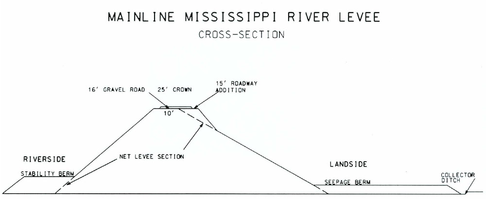
Figure 1. Illustration of a typical cross-section of the Mainline Mississippi River Levee. Courtesy of the Engineering Staff at the Mississippi Levee Board.
Materials and Methods
Imported fire ant mounds were located, measured (long axis, short axis, and height), and georeferenced at four levee locations (91° 04’ 48” W, 33° 22’ 12” N; 91° 08’ 31” W, 33° 19’ 18” N; 91° 08’ 32” W, 33° 19’ 29” N; and 91° 04’ 48” W, 33° 22’ 13” N) in western Mississippi, one oriented in an approximately east-west direction and three oriented in an approximately north-south direction. Three to five plots, each approximately 1500 m2, were established and geo-referenced at each location. Each plot was further divided into three subplots; two extended down the slopes from the road edge atop the levee to the landside and riverside berms, and one was located atop the relatively flat area adjacent to the levee on the landside berm (Figure 2). Mound activity (active or inactive) was assessed by probing each mound with a stick and watching for the emergence of workers. Only abandoned mounds that were in relatively good repair (i.e., it was not apparent that they were not occupied) were geo-referenced and measured. Above-ground mound volume (L) was estimated by using the formula for the volume of an oblique cone with a correction factor (Vogt 2007). Mound eccentricity in the plane of the ground was calculated as minor axis/major axis; mound area (m2) was calculated as the area of an ellipse [(0.5*major axis)*(0.5*minor axis)*p]. Plots were sampled from 25 June to 29 July 2003. During that period, the river stage (as measured at the Greenville, MS gage) ranged from 23 to 36.4 ft (7 to 11 m). The river was well below the bottom of the riverside slope during this time.
Spatial analyses were conducted by using ArcMap™ 9.2 (ESRI® Inc., Redlands, CA). Insolation (w*h/m2) was calculated from 1/3 Arc Second National Elevation Dataset Digital Elevation Models (available at the U. S. Geological Survey National Map Seamless Server, http://seamless.usgs.gov/; last accessed December 12, 2008). Point data for insolation were recorded for each geo-referenced point corresponding to a mound, and average insolation was calculated on a per-subplot basis.
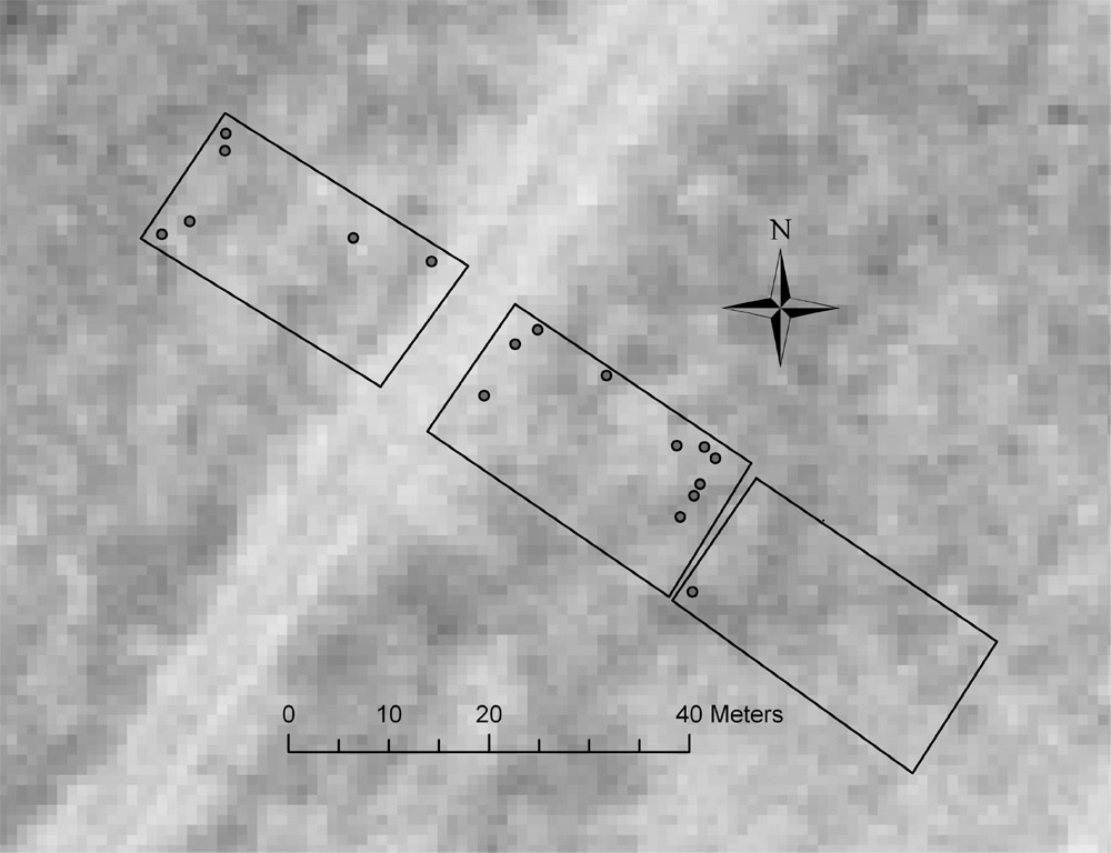
Figure 2. Aerial image (1.0-m U. S. Geological Survey black and white DOQQ) of a section of levee illustrating typical plot placement. The light area running southwest to northeast is the road surface on top of the levee; mound locations are indicated by shaded circles.
Individual mound characteristics [mound volume (L), mound area (m2), and eccentricity] were regressed over location (landside slope, landside berm, or riverside slope) and point data for insolation by using Proc Mixed (Littell et al. 1996) with plot as a random effect. Imported fire ant density was expressed as cumulative above-ground mound volume ha-1 (L), and number of mounds ha-1. These two dependent variables, along with percent inactive mounds per plot, were log10-transformed to stabilize variance, and regressed over average insolation (per subplot) and location (landside slope, riverside slope, or landslide berm) using Proc Mixed with plot as a random effect. Finally, the relationship between average mound size and mound density was examined by regressing average mound volume over mound density. Means comparisons were carried out using Least Squares Means, and differences were considered significant at a = 0.05.
Results and Discussion
Individual Mound Characteristics. Mound volume was negatively correlated with insolation (F = 13.2; df = 1, 430; P = 0.0013); this appeared to be due to a larger proportion of smaller mounds in areas of high insolation rather than a preponderance of large mounds in areas of low insolation (Figure 3). Location on levee did not significantly affect mound volume. Similar to volume, mound area in the plane of the ground decreased slightly with increasing insolation (F = 6.01; df = 1, 430; P = 0.0146). Mound area was slightly less on the landside slope (0.072 ± 0.009 m2) when compared with the landside berm (0.095 ± 0.009 m2) (Least Squares Means, P = 0.0165). There were no apparent relationships between mound eccentricity and location on levee or insolation. In general, mound size and shape were quite variable. Careful visual examination of geographic postplots did not reveal any distribution patterns related to distance from the road edge or base of levee.
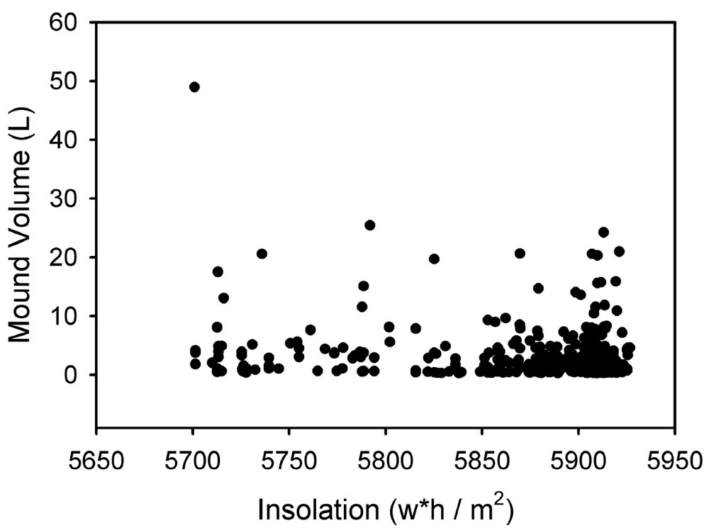
Figure 3. Relationship between individual imported fire ant mound volume and insolation.

Figure 4. Average cumulative above-ground mound volume for imported fire ants at three locations on the Mississippi River Mainline Levee; a = landside slope, b = landside berm, c = riverside slope.
Imported Fire Ant Density. Cumulative mound volume was related to location on the levee (F = 7.66; df = 2, 32; P = 0.0019) (Figure 4). There was no difference in cumulative volume between the landside and riverside slopes, but cumulative mound volume was significantly lower on the landside berm. Likewise, there was no difference in mound density between the landside and riverside slopes, but the landside berm had fewer mounds than either (F = 8.03; df = 2, 32; P = 0.0015) (Figure 5). Interestingly, there was no relationship between mean mound volume and number of mounds ha-1. The percentage of inactive mounds ranged from 0 to 66% (mean = 17 ± 4%) and was not dependent upon location or insolation.
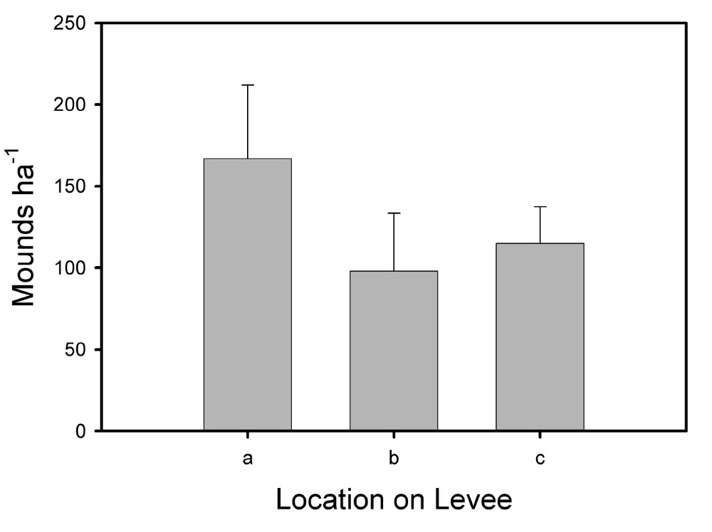
Figure 5. Average imported fire ant mound density at 3 locations on the Mississippi River Mainline Levee. A = landside slope, b = landside berm, c = riverside slope.
The lack of any significant relationship between cumulative mound volume or mounds ha-1 and insolation was surprising. In a study in Oklahoma, imported fire ant population density was positively correlated with insolation values up to 6000 w*h/m2 (as measured during the Summer Solstice) (Vogt et al., in press). Insolation was strongly correlated with location on the levee (F = 52.5; df = 2, 32; P < 0.0001) (5887, 5910, and 5822 w*h/m2 for location a, b, and c, respectively). This suggests that some optimal insolation level exists along the levee, most often on the landward slope (which faced south or east in the areas sampled). A quadratic relationship between cumulative mound volume and insolation approached significance (P = 0.1), further suggesting that population density increased to some optimal level and then decreased at the highest insolation levels. Imported fire ant populations might be influenced by other factors along the levee that were not measured in this study, such as soil moisture and vegetation density. The fact that smaller mounds were more abundant in the areas of highest insolation (Figure 3) suggests that different levels of insolation might favor colonies of different ages. This question would make an interesting avenue for future research, and might be useful for identifying areas that could serve as reservoirs for reinfestation of treated areas.
No effort was made to characterize fire ant populations as monogyne or polygyne. High mound densities (> 500 mounds ha-1) in several areas were indicative of polygyne populations. In general, population densities were similar to those encountered in pasture situations in Mississippi. The lack of any obvious spatial arrangement of mounds (for example, close to the road edge) has implications for control; any efforts to apply bait from the roadway atop the levee would have to include equipment capable of spreading a swath approximately 50 m wide or more to achieve sufficient coverage of both slopes or a unidirectional swath of approximately 25 m to cover one slope at a time. Future work should include efforts to ascertain the effects of mound building on infiltration and scrubbing under flood conditions to determine whether local control of imported fire ant populations is warranted.
Acknowledgments
I thank Alfred Martin and John Davis for their able assistance in the field. Peter Nimrod (Mississippi Levee Board), Johnny Kiser (U. S. Corps of Engineers), and two anonymous reviewers provided many helpful comments on an earlier draft of the manuscript.
References
Blust, W. E., B. H. Wilson, K. L. Koonce, B. D. Nelson, and J. E. Sedberry, Jr. 1982. The red imported fire ant, Solenopsis invicta Buren: cultural control and effect on hay meadows. Bulletin 738, Louisiana State University Agricultural Experiment Station. 27 pp.
Briano, J. A., R. S. Patterson, and H. A. Cordo. 1995. Colony movement of the black imported fire ant (Hymenoptera: Formicidae) in Argentina. Environmental Entomology 24: 1131-1134.
DeFauw, S. L., J. T. Vogt, and D. L. Boykin. 2008. Imported fire ant (Hymenoptera: Formicidae) bioturbation and its influences on soils and turfgrass in a sod production agroecosystem. Journal of Entomological Science 43: 121-127.
Green, W. P., D. E. Pettry, and R. E. Switzer. 1999. Impact of imported fire ants on Mississippi soils. Technical Bulletin 223, Mississippi Agricultural and Forestry Experiment Station. 39 pp.
Hays, S. B., P. M. Horton, J. A. Bass, and D. Stanley. 1982. Colony movement of imported fire ants. Journal of the Georgia Entomological Society 17: 266-274.
Henderson, G. 2008. The termite menace in New Orleans: did they cause the floodwalls to tumble? American Entomologist 54: 156-162.
Lafleur, B., L. M. Hooper-Bui, E. P. Mumma, and J. P. Geaghan. 2005. Soil fertility and plant growth in soils from pine forests and plantations: effect of invasive red imported fire ants Solenopsis invicta (Buren). Pedobiologia 49: 415-423.
Littell, R. C., G. A. Milliken, W. W. Stroup, and R. D. Wolfinger. 1996. SAS System for Mixed Models. SAS Institute, Cary, NC. 633 pp.
Lockaby, B. G., and J. C. Adams. 1985. Pedoturbation of a forest soil by fire ants. Soil Science Society of America Journal 49: 220-223.
Skinner, P. 2006. Levees – taking the long view. Pp. 25-41. In The Risk Management Yearbook. Public Entity Risk Institute (available online at: http://www.riskinstitute.org/
peri/images/file/06RMYearbook_levees.pdf; last accessed December 10, 2008).
Vogt, J. T. 2004. Detection of imported fire ant (Hymenoptera: Formicidae) mounds with satellite imagery. Environmental Entomology 33: 1718-1721.
Vogt, J. T. 2007. Three-dimensional sampling method for characterizing ant mounds. Florida Entomol. 90: 553-558.
Vogt, J. T., M. L. Allen, B. Wallet, D. Boykin, and W. A. Smith. 2009. Distribution patterns of imported fire ants (Hymenoptera: Formicidae) on a sheep and goat farm in Oklahoma. Environmental Entomology (Accepted).